

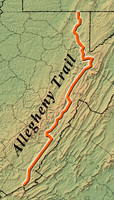
For nearly 300 miles, the Allegheny Trail traverses eastern West Virginia’s most inspiring scenery. Stretching from the state’s southeastern border with Virginia, a few miles east of Peterstown, Monroe County, to the Mason-Dixon Line near Morgantown, this hiking trail passes through several national forests, numerous state parks and forests, and private lands.
Connected at its southern end to the Appalachian Trail on Peters Mountain, the Allegheny Trail heads northeastward along the West Virginia-Virginia border for close to 50 miles. Turning northward, it crosses Pocahontas, Randolph, Tucker, and Preston counties on its way to Pennsylvania. The trail proceeds by way of the Greenbrier River, Glady Fork, Canaan Valley, and the Blackwater Canyon.
The Allegheny Trail is West Virginia’s longest trail. Conceived by members of the West Virginia Scenic Trails Association, construction of the pathway began in the 1970s. The route continues to be built and maintained primarily by members of the organization.
This Article was written by Leonard M. Adkins
Last Revised on December 07, 2010
Sources
Bird, Fred & Doug Wood. Hiking Guide to the Allegheny Trail. Charleston: West Virginia Scenic Trails Association, 1983.
Adkins, Leonard M. Along the Allegheny. Charleston Gazette, July 25, 1985.
Cite This Article
Adkins, Leonard M. "Allegheny Trail." e-WV: The West Virginia Encyclopedia. 07 December 2010. Web. 05 May 2024.
Comments?
There aren't any comments for this article yet.
Click here to read and contribute to the discussion →