 | Back to e-WV
| Back to e-WV
| Back to e-WV
Droop Mountain, located in Pocahontas and Greenbrier counties in West Virginia, peaks at 3,136 feet. Due to its crouched appearance as seen from the levels of the Greenbrier Valley and Hillsboro, it was originally called ‘‘Drooping Mountain.’’ The first known reference to the current name was in 1775, when Charles Kennison was excused from Botetourt Court due to the distance from his residence beyond ‘‘Droop Mountain.’’
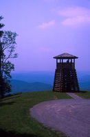
On November 6, 1863, Droop Mountain was the site of one of the most important Civil War battles fought on West Virginia soil. Confederate troops led by Brig. Gen. John Echols were defeated by a larger federal force led by Brig. Gen. William W. Averell. The West Virginia Fish and Game Commission purchased the site April 14, 1928, and dedicated Droop Mountain Battlefield State Park, now 287 acres, on July 4, 1928. In 1935, the Civilian Conservation Corps established Camp Price on the mountain. The CCC constructed footpaths throughout the property designed to highlight battle graves, breastworks, and battlefield monuments. Features of the park include picnic shelters, overnight cabins, a small Civil War museum, and an observation tower with a spectacular view of the surrounding countryside.
Droop Mountain’s forests underwent considerable change in the early part of the 20th century. The magnificent American chestnut trees, which had made up as much as 25 percent of the forest in the area, were ravaged by a blight introduced to America from Asia in 1904. In addition, the effects of early logging practices and the severe drought of the 1930s combined to make conditions ripe for major forest fires. Following the fires, a sawmill was set up to salvage usable timber. As logs were processed at this mill, minié balls from the Civil War were frequently found embedded in the wood. Many of the original structures at Watoga and Babcock state parks are constructed of this salvaged timber. Today, the reforested mountain is thick with mature native hardwoods and evergreens. A distinctive feature of the area is the cranberry bog, an acidic wetland more commonly found in the northern United States and Canada.
On October 18, 2021, the International Dark Sky Association named Droop Mountain Battlefield State Park, along with Watoga State Park and Calvin W. Price State Forest, as West Virginia’s first Dark Sky Parks. The expansive night skies and low light pollution are a boon to astronomers and anyone seeking a clear view of the Milky Way. The designation is “based on the quality of the night skies, stringent outdoor lighting standards, and innovative community outreach.”
U.S. 219 crosses Droop Mountain on the way from Lewisburg to Marlinton.
Written by Hallie Chillag Dunlap
Pocahontas County Historical Society. History of Pocahontas County. Marlinton: 1981.
Lowry, Terry. Last Sleep: The Battle of Droop Mountain. Charleston: Pictorial Histories Publishing Company, 1996.
West Virginia Celebrates Three New Dark Sky Parks. International Dark-Sky Association, October 18, 2021.
United States Geological Survey Maps,