 | Back to e-WV
| Back to e-WV
| Back to e-WV
The Blue Ridge, an Appalachian mountain range that stretches from eastern Pennsylvania to northern Georgia, crosses the easternmost tip of West Virginia. Its crest forms the boundary between Jefferson County, West Virginia, and Loudoun County, Virginia. Farther south in Virginia the Blue Ridge reaches elevations above 5,000 feet, but it reaches only 1,700 feet in West Virginia. The Shenandoah Valley separates the Blue Ridge from the Allegheny Mountains to the west. The oldest surface rocks in West Virginia, mostly sandstones, occur on the Blue Ridge. The very oldest is the Catoctin greenstone, a type of basalt that formed from 600-million-year-old lava flows that were altered by later geologic pressure.
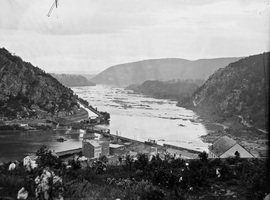
The Blue Ridge was a formidable barrier to westward expansion during colonial times. Early European explorers such as John Lederer, Thomas Batts, and Robert Fallam penetrated the Blue Ridge in Virginia in the 1670s. However, most early explorations of the Blue Ridge and its passes in Virginia had little direct influence on the earliest settlement of West Virginia. The earliest settlements were primarily the result of explorations to the north, which found routes through the Blue Ridge in Pennsylvania, Maryland, and most notably, at a significant break in the Blue Ridge at Harpers Ferry. Here the Shenandoah and Potomac rivers meet, cutting a dramatic gap through the mountain.
This gap, at 247 feet above sea level, is the lowest point in West Virginia. In 1702, the Swiss explorer Franz Louis Michel explored the Potomac region through the Harpers Ferry gap. In 1707, he created a map depicting the region. A Swiss associate, Baron Christopher de Graffenreid, produced a map of the area in 1712. These and other maps, along with tales told by Dutch and French traders of the fertile Shenandoah and South Branch valleys, lured German, English, and other immigrants into present Berkeley, Jefferson, Hampshire, and Hardy counties via Harpers Ferry and other northerly routes in the 1730s and 1740s. To the south, the Blue Ridge would remain a barrier, initially restricting immigration from eastern Virginia to a slow trickle. Consequently, the early settlers of West Virginia often did not come from eastern Virginia, but instead from Maryland, Pennsylvania, or New York. This pattern of immigration contributed to the social divisions that led to West Virginia statehood during the Civil War.
As transportation improved, the gap at Harpers Ferry became increasingly important for passage through the Blue Ridge. Both the Chesapeake & Ohio Canal and the Baltimore & Ohio Railroad were built through the gap. Control of the passage of goods and soldiers through the gap was a major objective of both Union and Confederate armies throughout the Civil War.
Historically, the mountain supported forests, small farms, resorts, and some mining of iron ore. Today, much of the Blue Ridge in West Virginia has been developed for residential use. Portions of the mountain are protected lands within Harpers Ferry National Historical Park and Shannondale Springs Wildlife Management Area. The famous Appalachian Trail follows a narrow corridor along the mountain’s crest, and the trail’s national headquarters is located in Harpers Ferry.
Written by Rodney Bartgis